“PC23-1045PSU”
Such a bureaucratic name to a proposal that has been in development for over 100 years.
Timeline of Major Changes Since 1927
- 1927: Charles Lindbergh completes the first solo nonstop transatlantic flight.
- 1929: Stock Market Crash sparks the Great Depression.
- 1945: End of World War II; United Nations is formed.
- 1957: Launch of Sputnik by the Soviet Union, beginning the Space Race.
- 1969: Neil Armstrong becomes the first human to walk on the Moon.
- 1989: Fall of the Berlin Wall, symbolizing the end of the Cold War.
- 1991: Dissolution of the Soviet Union.
- 2001: September 11 terrorist attacks reshape global security policies.
- 2008: Global financial crisis begins; Barack Obama becomes the first African American U.S. President.
- 2020: COVID-19 pandemic leads to worldwide disruptions.
- 2022: Russia invades Ukraine, sparking ongoing global tensions.
Yet somehow, the engineering and planning professionals employed by the city of Frederick say that nothing has changed in the past 98 years, and that the infrastructure that was last laid out in the 1950’s is perfectly adequate to support the development of 50 new single-family homes. In fact, residents were told that we should be happy that the developer has dropped that number from 60 due to concerns around storm water retention.
What is being proposed:
OWNER:
BARBARA FRITCHIE, INC. AND
SEAN FILLINICH, TRUSTEE OF THE
BLUE DIAMOND TRUST
10738 TUCKER STREET, SUITE A,
BELTSVILLE MD 20705
PHONE: 240-876-2533
EMAIL: soundworksmd@yahoo.com
City Minimums:
Sec. 405 – DIMENSIONAL AND DENSITY REGULATIONS
ZONING DISTRICT: R6 SINGLE-FAMILY DWELLING
PERMITTED/REQUIRED PROVIDED THIS PLAN
MINIMUM LOT SIZE (SQUARE FEET): 7,000 SF 7,000 SF (0.16 ACRES)
MAXIMUM DENSITY: 6.0 DU/AC 50 DU
OR 80.8 DU OR 4.4 DU/AC
MINIMUM FRONTAGE (FEET): 50 FT 50.0 FT
MAXIMUM BUILDING HEIGHT (FEET): 35 FT(1) 35 FT
MINIMUM FRONT STREET SETBACK: 25 FT 25.0 FT
MINIMUM INTERIOR SETBACK (FEET): 8 FT 8.0 FT
MINIMUM REAR SETBACK: 30 FT 30.0 FT
IMPERVIOUS SURFACE RATIO: 0.5 0.4
PARKING AND LOADING STANDARDS 2.0 PER UNIT 100 PARKING SPACES
OR OR
100 PARKING SPACES 2.0 PER UNIT(2)
(1) IN THE R4 AND R6 DISTRICTS, THE MAXIMUM BUILDING HEIGHT OF A STRUCTURE;
(A) WITH A FLAT ROOF IS 35 FEET AS MEASURED TO THE HIGHEST POINT OF THE ROOF; AND
(B) WITH A PITCHED ROOF IS 35 FEET AS MEASURED AT THE MIDPOINT BETWEEN THE EAVES AND THE HIGHEST POINT OF
THE ROOF, NOT TO EXCEED 40 FEET AT ITS HIGHEST POINT.
(2) EACH DWELLING UNIT WILL INCLUDE AN ATTACHED 2 CAR GARAGE, FURTHER, EACH DRIVEWAY WILL ACCOMMODATE AT
LEAST 1 ADDITIONAL PARKING SPACE.
PRELIMINARY PLAT NOTES:
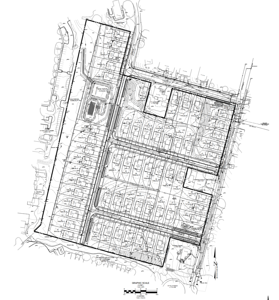
- This Preliminary Subdivision Plat proposes establishment of 56 single family residential lots,
supporting roads and infrastructure. - The Site is Zoned R-6 (Low-Density Residential).
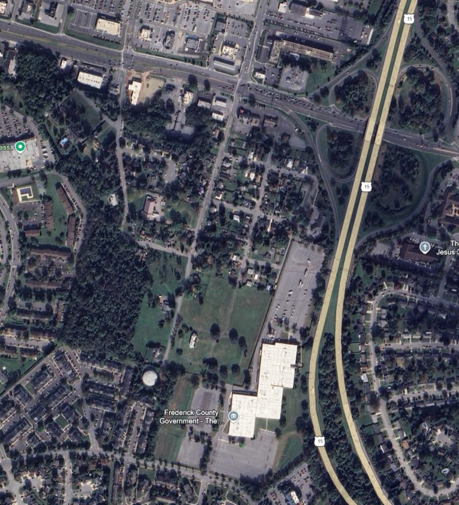
- Site is 13.47 Acres and is found in the the Frederick County Land Records at:
L.15347 F. 436 - Existing Use – Vacant
- Proposed Use – Single Family Residential
- Permitted Residential Density – 6.0 du/ac. x 13.47 ac. = 80.8 du’s allowed, 50 du’s proposed.
- Water and Sewer Classification: W-1 and S-1
- Water is readily available and will be extended from Existing Poplar Street and Linden Place to serve the development. The water mains will be connected and “looped ” along Hoke Place, Birch, and Maple Streets. Sewer is currently available along Poplar Street and Linden Avenue to serve the properties that front these streets. The existing sewer along a portion of Birch and Maple Street will be replaced at a lower elevation to serve the lots that front these new sewer mains. A portion of the site will be serviced by a
pressure sewer that will pump five (5) lots along Hoke Place. The pressure sewer will transition to the gravity system through a new sewer manhole on Poplar Street. To serve these lots by gravity would require a manhole over 25′ in depth; we believe this is an impractical depth. A previous force main had been pproved to serve this portion of the property, see plan SS-10-753. - Total Parkland Area Required = 500 SF/unit or 50 units x 500 SF=25,000 SF or 0.5739 Acres required. Because this is below the three acre threshold generally deemed viable for parkland dedication, the applicant requests a fee in-lieu of dedication.
- There are no floodplains on site.
- There are no wetlands on site.
- Streetlights will be provided in conformance with City of Frederick Standards.
- Trash will be collected by City of Frederick.
- Proposed Roads all have an established 50′ Right-of-way and will be constructed as City of Frederick local roads. The layout completes the previously established grid-style layout of Hoke Place, Birch Street, and Maple Street.
- Stormwater Management will follow Environmental Site Design (ESD) Guidelines to the Maximum Extend Practicable (MEP). All ESD facilities will be maintained by the Homeowners Association.
- Forest Stand Delineation STF23-183FSD was approved on July 12, 2023.
- Forest Conservation – Per section 721 of the Land Management Code, Forest Conservation is being addressed as follows: 1.16 acres of forest is to be retained in an on-site forest conservation easement; 4.64 acres of reforestation met via 88 trees proposed for street tree credit of 1.94 acres and the remaining 2.70 acres to be met by fee-in lieu.
- Traffic Study is not required.
- All sidewalks are 5′ wide unless otherwise specified. All public and private streets with sidewalks shall be provided with ADA accessible sidewalk ramps.
- All road intersection curb fillets are 25′ unless otherwise noted on plan.
- All paving marking shall be in accordance with the latest MDSHA-MUTCD standards & specifications.
- All signs, street markings, and maintenance of traffic required is to be in compliance with the current “Maryland SHA Manual on Uniform Traffic Control Devices”.
- This Preliminary Plat was prepared without the benefit of a title report.
- The Topography shown is from a photogrammetric survey conducted by McKenzie Snyder, Inc. dated December 2022 and supplemented with additional field run survey prepared by MHG, P.A. dated January 2023.
- Boundary Information has been provided by MHG, P.A
The full plat and proposal can be seen here.
So what’s the issue?
“Growth for the sake of growth is the ideology of the cancer cell.”
Edward Abbey.
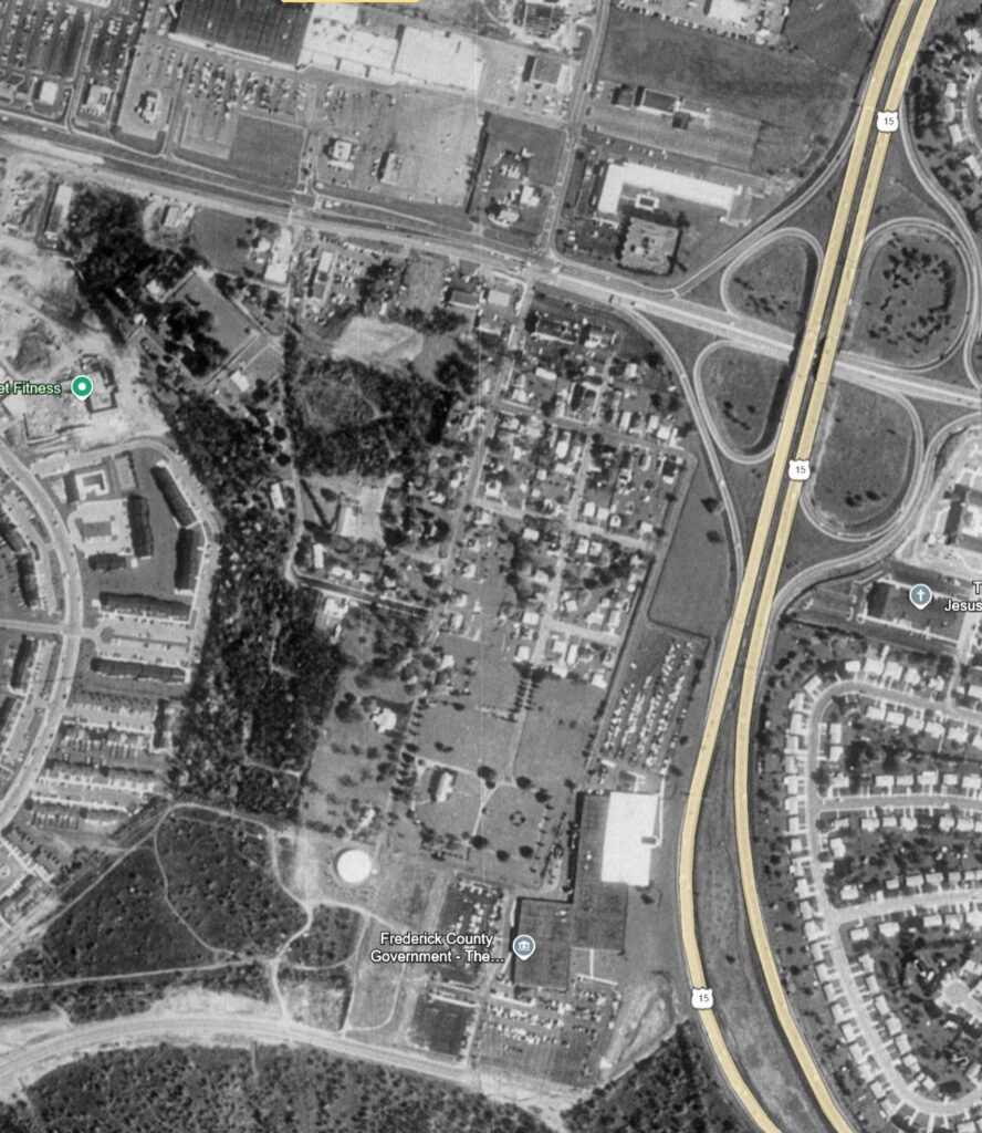
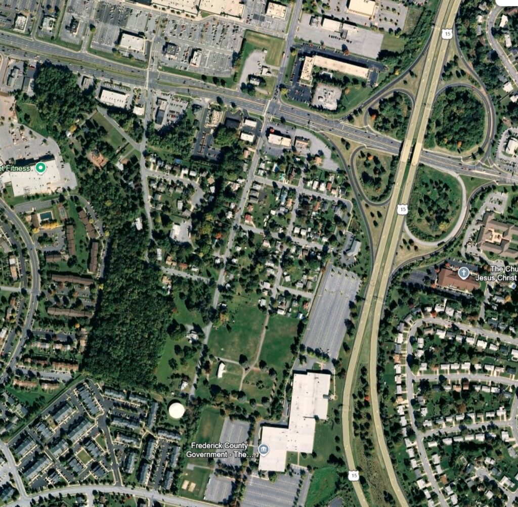
The problem with the development plan is that the infrastructure for the proposed development was laid out in the 1920’s and last revised in the 1950’s. Due to the changes to infrastructure and the cities respective growth, much has changed in the past 70 years, but the City of Frederick’s stance is that “this has been in the pipeline”, regardless of actual feasibility.
For more information, explore the detailed history of Linden Hills in our dedicated post: “Linden Hills: A Journey Through Time.”
Traffic
Issue: The widening of Route 15 through the City in the near future means traffic congestion will increase around the Rt. 15 and Rt. 40 interchange. The development proposal will add 150 – 300 cars in addition to the 100+ cars that already exist in the neighborhood.
Issue: Existing businesses along Linden Ave and Hoke Pl already dump traffic directly onto those streets instead of Rt. 40. The addition of the county maintenance and parking lot along Oak St has increased traffic flow in and out of Linden Ave. This results in significant backups during normal traffic days, and congestion or incidents along Rt. 15 southbound result in the intersection being blocked, preventing egress of the neighborhood.
Issue: Linden Ave and Hoke Pl are narrow streets with current frontage accommodating 2 lanes of street parking and 1.5 lanes for traffic. The proposed development extends beyond this frontage, leaving enough space for only 2 traffic lanes.
Issue: The absence of sidewalks on both Hoke Pl and Linden Ave forces pedestrians to walk directly on the street, creating a hazardous situation, especially with the increased traffic volume. While the developer has proposed constructing sidewalks, their plan only covers the portion of land they own, leaving gaps and resulting in an incomplete “sidewalk to nowhere.”
Utilities
Safety: The existing water main does not have the capacity to support additional homes and fire hydrants due to age and distance. Due to density of the proposed homes, (50 foot wide lots with 16 foot distance homes), this is a significant public safety concern as a lack of water pressure would result in a rapid spread of any blazes that occur.
Issue: There are no natural gas main on Linden Ave, the new homes will be all electric, however it is unclear if the local power lines have capacity given their age to support modern construction.
Issue: The water mains for Linden Ave were laid out in the 1940’s, and is sized at 8 inches. Today, there are significant pressure drops for that main during normal use, without the additional 50 homes.
Issue: Utilities for the neighborhood are above ground, including 13.6kV transmission lines that feed local substations from Potomac Edison. These lines run past the proposed development, with no apparent plan to compensate for the need to bury them based on the planning design.
Greenspace
The developer is proposing to pay a fee “in lieu” of actually conserving forest land. 13.8 acres of forest exist today, with the proposal to shrink that down to just 2-3 acres. There is also no plan for affordable units, with the developer paying a $200,000 “fee” instead of making affordable units.
Leave a Reply